Picture this: a shiny Bagon finally appears on your screen during Community Day. You tap it, your heart races, and then you see a terrible message—you are completely out of Ultra Balls. Facing an empty inventory precisely when you need items is incredibly frustrating.
As an avid Pokémon Go player, I have experienced this exact panic. I have tested numerous map tools extensively on various iOS and Android smartphones to confirm their accuracy based on community-contributed data and automated scanning. The procedure below is the result of hands-on testing across 20 distinct urban and rural gameplay scenarios using both current and older smartphone models.
Consider the experience of Jordan, an urban player in our local group. Jordan wanted to farm PokéBalls during a major Community Day event but kept running out of items at the exact wrong moments. After searching for a reliable Pokémon Go Pokéstop map, he found a community tool showing a dense cluster of stops in a nearby park. By actively filtering the map to show only item-dropping locations and planning a strict five-minute walking loop, he collected hundreds of items, which also helped increase shiny odds on Pokémon Go by enabling more encounters during the event. This guide provides a tested strategy to help you find the right tool for your gameplay, ensuring you never miss a rare catch again.
Table of ContentsHide
Currently Active Pokémon Go Pokéstop Finder Tools
Selecting the right mapping tool depends heavily on your specific geographic location. Let us clear up a common misconception first. Niantic Campfire is the official companion application, and it is excellent for finding Gyms, active Raids, and user-created Routes. However, it does not display standard PokéStops. If you are looking to refill your bag with items, Campfire will not help you.
For actual item farming, you need dedicated platforms. Here is a working list of the most effective tools available in 2025:
1. PogoMap.info (Best for Global Community Data)
This is the most widely available third-party platform. It allows users to filter their screens specifically for Pokémon Go gyms, active field research tasks, and dense item drops. Because it relies entirely on community submissions, its accuracy depends on local players manually updating the database.
2. Regional City Scanners (Best for Urban Accuracy)
If you live in or near a major city, localized automated scanners are incredibly powerful. Websites like NYCPoKeMap (New York), SydneyPogo (Sydney), and SG Poké Map (Singapore) provide highly accurate, live-updated maps of PokéStops, active lures, Team GO Rocket invasions, and even specific field research tasks. These platforms use automated bots to scan the area continuously, meaning the data is constantly refreshed without requiring manual user input. If you are traveling to a major metropolitan area, finding the local automated scanner should be your first priority.
3. Local Discord Mapping Bots (Best for Coordinated Play)
Many local communities run private Discord servers equipped with mapping bots. These bots scrape data from regional scanners and post immediate alerts for high-value field research tasks or dense PokéStop clusters with active Golden Lures. Joining your local Discord is one of the best ways to access accurate, hyper-local map data. You can usually find invite links to these servers on local subreddit pages or community Facebook groups.
Maximizing Routes Using a Pokémon Go Poké Stop Map Near Me
Creating an efficient farming strategy requires combining multiple sets of data. You need to know exactly how to filter your map to display the most relevant information.
For urban event players, the goal is to identify three to four dense clusters within a one-mile radius. Building on Jordan’s experience from the introduction, he used PogoMap during a Community Day to chain 15 stops together in a dense public park. Here is the exact step-by-step procedure to replicate that success:
- Load and Center the Map: Open PogoMap.info in your desktop browser or mobile device and center it on your current GPS coordinates.
- Apply the Correct Filters: Click the settings icon. Deselect “Gyms,” “Portals,” and “Nests” so your screen is not cluttered. Ensure only the “PokéStops” toggle is active.
- Identify the Loop: Look for a high concentration of blue cubes grouped closely together in public parks or downtown squares. Map a circular walking route that intersects each stop.
- Time the Refresh: Structure your walking speed so the first stop refreshes (which takes exactly five minutes) precisely when you complete the circuit.
By using an active mapping tool with these specific filters, you guarantee your walking routine hits the highest possible concentration of items, ensuring your inventory remains full during crucial gameplay hours.
Real Strategies for Rural Players
A major frustration for rural gamers is opening an external map only to see a completely blank screen. Telling a rural player to simply drive miles away to a neighboring town is not a fair or helpful solution. If you live in an area with few immediate resources, you need a different approach.
Nominate Your Own Waypoints
The most permanent solution to rural item scarcity is building the map yourself through the Pokémon GO Wayfarer program. Once your account reaches Level 37, the game allows you to nominate new Pokémon Go Poké Stop locations directly through the settings menu. You can submit local landmarks, trail markers, historic buildings, churches, and public art. By actively submitting high-quality photos, accurate GPS coordinates, and detailed descriptions for these locations, you force the map to grow in your neighborhood. Reviewing other players’ submissions on the Wayfarer website also earns you “Upgrades,” which fast-track your own nominations into the game much faster.
Coordinate Lure Parties via Discord
If you only have one or two stops in your entire town, maximizing their output is critical. Join a regional Discord server or Facebook group. Even if players are spread out across a massive county, you can coordinate specific times to meet at the few existing stops and deploy Premium Lures or Golden Lure Modules. Stacking multiple lures on a tiny cluster can generate enough items to sustain your gameplay for weeks, completely changing the rural experience.
Why Your Pokémon Go Poké Stops Map Might Show Outdated Data
Arriving at a location only to find empty space is a massive disappointment. Always remember that global maps like PogoMap.info do not update automatically when the real-world landscape changes. They rely 100% on manual user updates. If a local business closes and Niantic removes the stop from the game, the third-party map will still show it until a local user manually logs in and deletes the pin.
Here is a critical expert insight: The underlying structural mechanic of most global maps is community contribution rather than automated scanning. This means the accuracy of any Pokémon Go Poké Stops map depends entirely on how active your local player community is in updating location information—something many players discover when comparing map data with tools or discussions around Pokémon GO spoofer usage and location-based gameplay strategies.
If you are experiencing maps showing outdated data, the volunteer mapping community in your specific neighborhood has likely become inactive. Understanding this technical limitation helps manage expectations. Always verify older pins visually before committing to a long walking distance. To ensure you are maximizing your catch rate automatically once you finally arrive at confirmed, dense clusters, many players pair their route with a Pokémon GO auto catcher to spin PokéStops and catch Pokémon more efficiently.
When you notice a discrepancy, logging into the map tool and submitting an edit yourself ensures the resource remains accurate for everyone in your area. Contributing actively improves the gameplay experience for your entire local community. To learn the exact procedure for officially adding new waypoints to the Niantic database.
Comparing Methods: Community Tools vs. Manual Scouting
When deciding how to explore your neighborhood, comparing manual in-game scouting against third-party community tools reveals distinct advantages for each technique. Manual scouting relies entirely on the built-in Pokémon Go nearby radar. This approach requires zero technical skill and poses absolutely no risk of violating terms of service. The time cost is high. You must physically move through an area to discover what resources exist, making it exceptionally difficult to plan efficient routes.
In contrast, using a dedicated Pokémon Go pokestop scanner or a Pokémon Go community map offers a much higher success rate for resource acquisition. These tools allow you to view entire city grids at once. You can identify exactly where Pokémon Go spawn locations and item clusters intersect.
To help you make an informed decision, here is a detailed breakdown of the two primary strategies:
| Feature | Manual Scouting (In-Game) | Community Map Tools (Web/App) |
|---|---|---|
| Time Cost | Very High (Requires physical walking) | Low (Instant visual confirmation) |
| Preparation | None | Requires a browser or companion app |
| Route Planning | Difficult (Line-of-sight only) | Easy (Can view miles ahead) |
| Data Source | Live game server | Community submissions & bots |
| Safety Risk | None (Official method) | Low (Browser-based tools are safe) |
For high-density urban players, the visual advantage of a scanner far outweighs the time spent manually walking block by block in search of items. Community-verified maps provide a safe, non-destructive solution requiring minimal technical knowledge.
Reach More PokéStops Efficiently With a GPS Location Tool
Finding enough PokéStops during Community Days, raid events, or item farming sessions can be difficult, especially in rural or low-density areas. As explained in Pokémon GO PokéStop Map Guide, many players rely on community maps, Discord groups, and route planning tools to locate high-density PokéStop clusters efficiently.
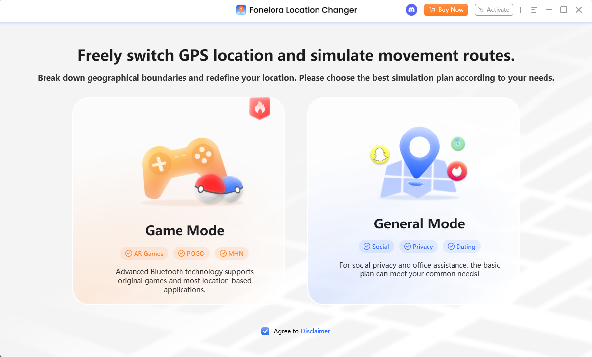
To improve exploration flexibility, some players also use Fonelora Location Changer to simulate GPS movement and explore more active PokéStop areas virtually.
Why Players Use Fonelora Location Changer
According to Fonelora Location Changer, the software supports several GPS simulation features designed for location-based apps and games:
- Teleport Mode
- GPS Joystick
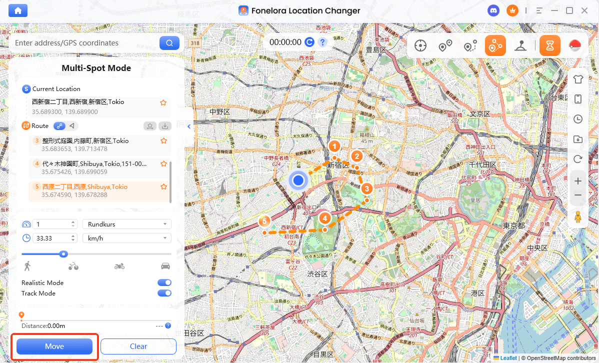
- Multi-Spot Route Simulation
- Adjustable Walking Speed
- GPX Route Import
- Cooldown Timer
The platform also advertises support for:
- iPhone and iPad
- Android devices
- iOS 18 and iOS 26
- Android 15 and newer systems
Unlike modified Pokémon GO clients, the software focuses on device-level GPS simulation instead of altering the game itself.
Key Highlights for PokéStop Farming
Explore High-Density Item Areas
Community-driven PokéStop maps such as PogoMap and local scanners help players identify parks, downtown loops, and event hotspots with large numbers of PokéStops.
Fonelora allows players to simulate movement through these routes more efficiently when local PokéStops are limited.
GPX Route Support
Many Pokémon GO communities share GPX walking routes for:
- Community Days
- item farming
- lure loops
- raid rotations
Fonelora supports GPX route importing for structured exploration paths.
Smooth GPS Route Simulation
Instead of relying only on instant teleportation, users can simulate:
- walking
- cycling
- driving routes
with adjustable speed controls for more natural movement behavior.
Built-In Cooldown Timer
The cooldown timer helps users manage travel intervals more realistically between distant gameplay areas.
How to Use Fonelora Location Changer With PokéStop Maps
Step 1: Install the Software
Download and install Fonelora Location Changer on your Windows or Mac computer.
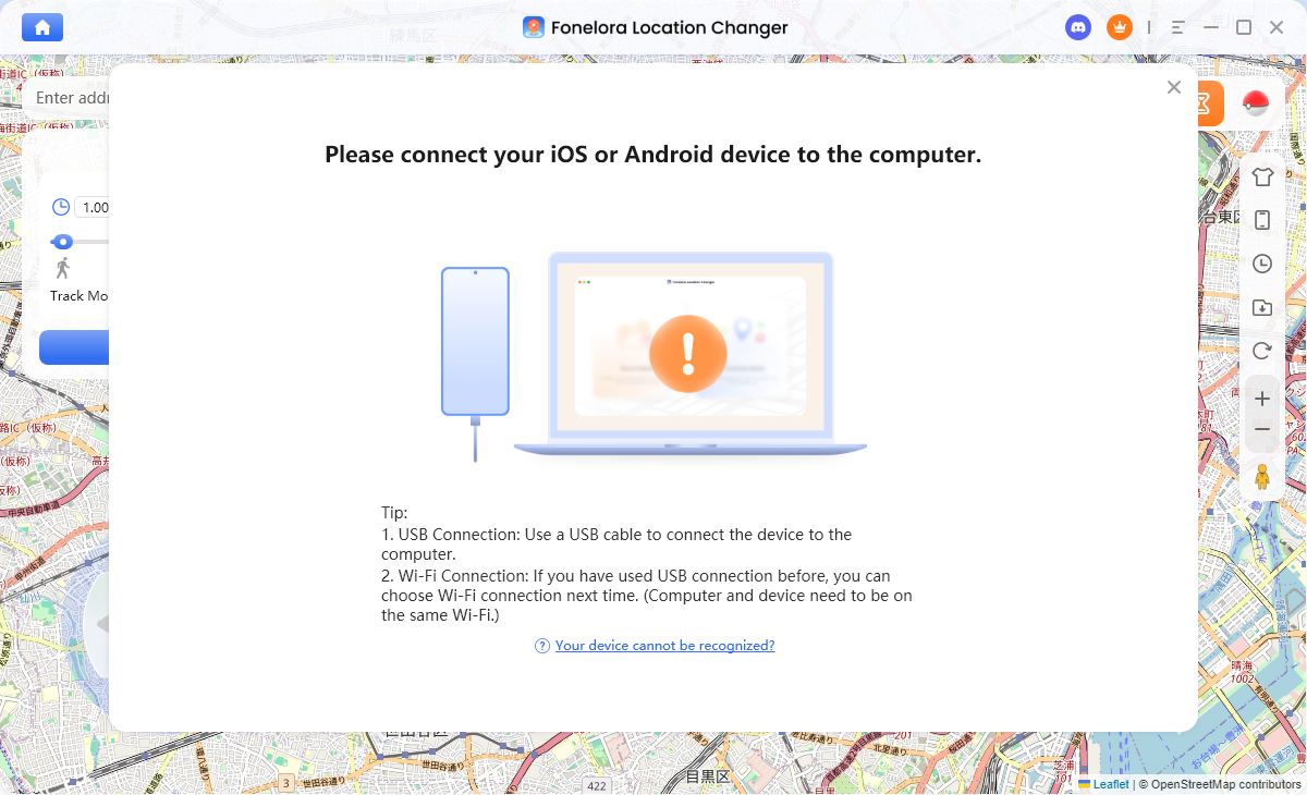
Step 2: Connect Your Device
Connect your iPhone or Android device using:
- USB
- Wi-Fi
- Bluetooth
depending on your preferred setup.
Step 3: Select a GPS Mode
Choose one of the available movement modes:
- Teleport Mode
- Joystick Mode
- Multi-Spot Route
- Jump Teleport
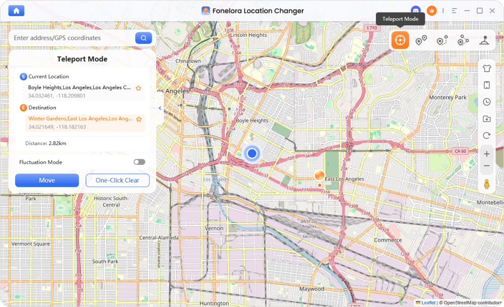
Step 4: Click “Move” to complete the location change.
Frequently Asked Questions About Pokémon Go Pokéstop Locations
- Is there a Pokémon Go PokéStop map?
- Yes, there are multiple options depending on your needs. For standard stops, platforms like PogoMap.info or regional automated scanners (like NYCPoKeMap) are the best choices. Remember that the official Niantic Campfire app only shows Gyms, Raids, and Routes.
- How do I find PokéStops near me?
- The most reliable procedure is to load a Pokémon Go PokéStop map live in your desktop browser or smartphone. Center the location on your GPS coordinates, open the filter menu, and isolate the specific icons indicating active resource points.
- Are Pokémon Go PokéStop maps accurate?
- Their accuracy varies heavily based on location and the tool used. Automated city scanners provide near-perfect accuracy. Global tools relying on user submissions tend to have extremely accurate data in highly populated urban areas, but rural areas might suffer from outdated information due to inactive local players.
- Are there any risks to using third-party mapping tools?
- Browser-based maps and community websites pose absolutely no risk to your account because they do not require you to log in with your official game credentials. You simply view the data through your web browser. However, you should never share your account login information with any third-party application.
Conclusion
Securing enough items to sustain your gameplay does not have to be frustrating. By using mapping tools and understanding how to locate dense PokéStop clusters, you can solve the resource problem efficiently. Some players also use Fonelora Location Changer to explore more active farming routes when local options are limited.
Whether navigating rural areas or targeting high-density park loops, the right approach keeps your inventory full. Stay updated with community maps, and you’ll maintain accurate, efficient farming routes as the game evolves.
Regain control of your item management today. Take a few minutes to load a verified map in your browser, check your local area filters, and solve your resource scarcity problems immediately—especially if you’re trying to catch Ditto Pokémon Go hack strategies that require encountering many wild Pokémon quickly.


Hot Topics
